The Leaning Tower of St. Moritz is a 12th-century church tower located in the Swiss Alps. It is one of the most iconic landmarks in the town of St. Moritz and is known for its distinct tilt. The tower is 33 meters high and leans 5.5 degrees to the north. The Leaning Tower of St. Moritz has been associated with the landslide occurring in the area.
For the past 30 years, the Institute of Geotechnical Engineering at ETH Zurich has been actively involved in all aspects of the problem related to geotechnical engineering, both through research and by providing expert services to the community.
According to Alonso et al. (2010), the slope above the village of St. Moritz is unstable and can be divided into two parts: the Gianda Laret rockfall and the Brattas landslide as shown in Figure 1. The Gianda Laret rockfall is located at the top of the slope and extends down to an altitude of 2100 meters.
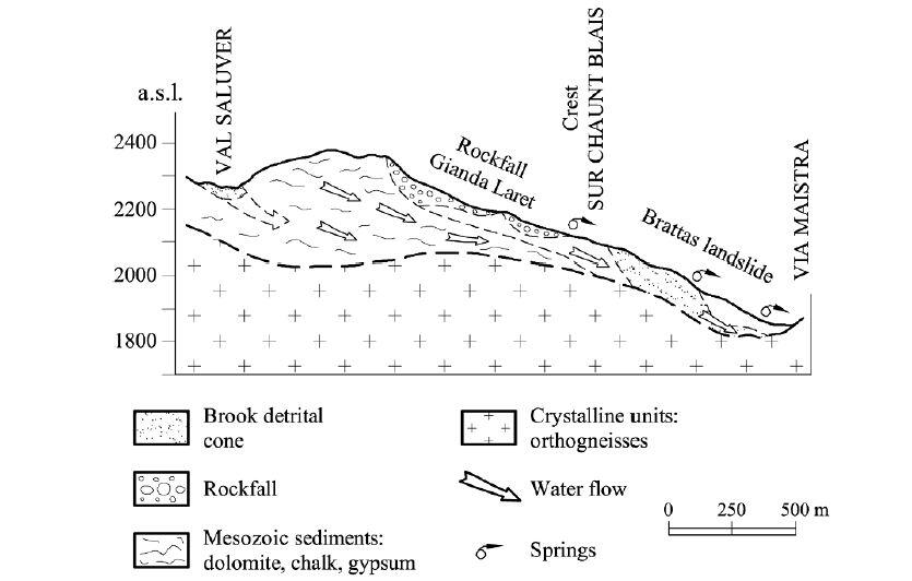
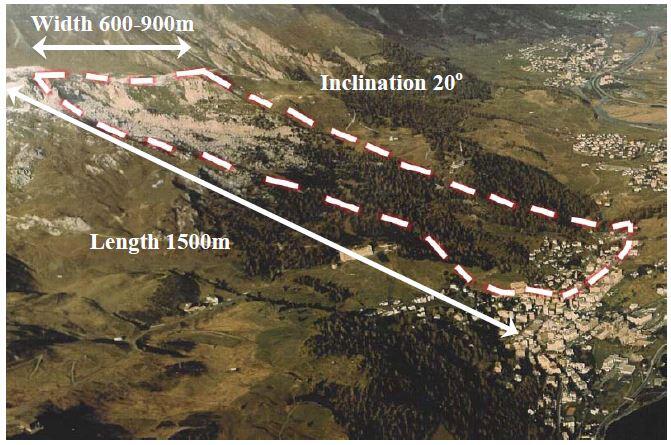
The Brattas landslide is located below the rockfall and is composed of a thick layer of soil. The landslide is moving downhill but is blocked by a ridge. The Brattas landslide is 600 meters wide and has an average slope of 20 degrees (see Figure 2). The main sliding surface of the landslide is about 50 meters deep. The Brattas landslide is made up of different layers of soil, which vary in thickness and properties.
The road Via Maistra is getting narrower by about 0.5 centimetres per year at the point where it is closest to the Brattas landslide. The displacement rate of the landslide increases uphill from Via Maistra. The movement of the landslide has only been measured in the developed areas, so it is not known if there is any interaction between the Gianda Laret rockfall and the Brattas landslide.
The Leaning Tower of St. Moritz
The effects of the Brattas landslide are most evident in the behaviour of the oldest structures in the area. The Leaning Tower of St. Moritz Church, which was built in the 12th century at the foot of the landslide, leans 5 degrees off-centre. The church itself was demolished in 1893 due to excessive differential settlement.
Since 1908, regular measurements have been taken to track the tilt and displacement of the tower. Stabilization efforts in 1928 and 1968 were not successful in the long term. In 1976, the tower reacted alarmingly to an earthquake in Friaul, Italy. As a result, another stabilization attempt was undertaken in 1983.
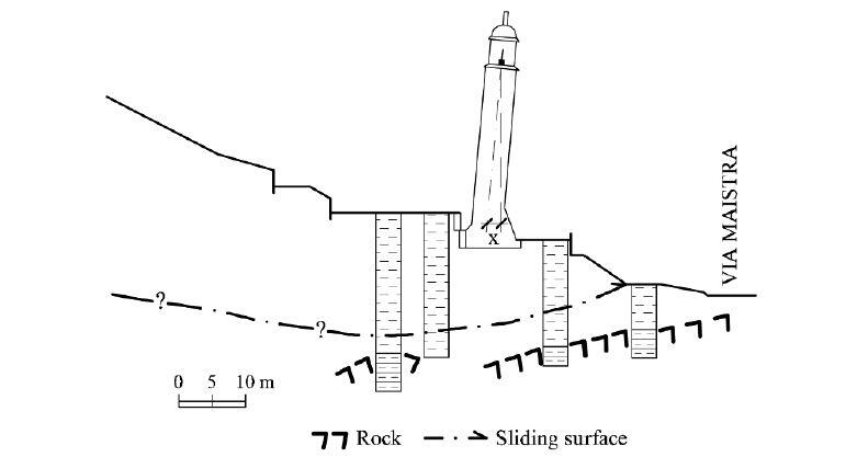
In 2013, the Leaning Tower of St. Moritz underwent a major renovation to reduce its tilt and improve its stability. The renovation involved removing some of the weight from the top of the tower and reinforcing the foundation. The renovation was successful, and the tower is now considered to be safe and stable.
The Problem
The Brattas landslide is caused by a combination of geological and hydrological factors. The landslide is located in a region where the Mesozoic sediments of the Bernina nappe have been pushed over the crystalline rock of the Err nappe. A nappe is a large sheet of rock that has been moved a long distance from its original position.
The landslide is also affected by the presence of deep aquifers, which create independent water tables. When the snow melts in the spring, the water pressure in the aquifers increases. This can reduce the shear strength of the soil and lead to landslides. Small landslides occur in the Brattas area every year, but larger landslides can also occur less frequently.
Landslide Stability Analysis
Puzrin and Sterba (2006) developed a simple model of a constrained landslide to assess the long-term stability and displacements of the St. Moritz landslide. The model is based on an inverse analysis, which means that the safety factor is determined by fitting the model to the observed displacement data.
In 2005, Puzrin performed a preliminary stability analysis of the Brattas landslide using the displacement data that was available at the time. The data was collected from the lower 200 meters of the landslide. Puzrin assumed that the two parts of the landslide were connected, and that the total length of the landslide was 1500 meters. He then used the equation developed by Puzrin and Sterba (2006) to fit the displacement data. This produced a ratio of b/a = 0.39.
Puzrin then assumed that the effective angle of internal friction was within the range of 28 to 35 degrees, as suggested by Vermeer (1997). For the average slope of 20 degrees, this gave a value of pa′/pp′ = 0.28 − 0.15. The corresponding safety factor was calculated to be Fs = 0.78 −1.46.
Puzrin’s preliminary analysis suggested that the Brattas landslide was marginally stable, but it did not exclude the possibility of failure. To improve the accuracy of the prediction, more data was collected from the middle and upper parts of the landslide. This data showed that the movement rate at the top of the landslide was significantly higher than at the bottom of the Gianda Laret rockfall.
This suggests that the rockfall movement is stopped by a rock ridge and does not fully transfer earth pressures to the Brattas landslide. However, the upper boundary of the Brattas landslide is slowly shifting upwards as blocks from the rock ridge collapse into the sliding mass.
Based on the latest data, the authors assume that there is no interaction between the Gianda Laret rockfall and the Brattas landslide. They then use a revised version of the Puzrin and Sterba (2006) equation to fit the displacement data. This gives a ratio of b/a = 0.15 and a safety factor of Fs = 2.49 − 4.63.
This suggests that the Brattas landslide is stable and that there is no risk of failure in the near future. However, the authors caution that this conclusion is preliminary, as the observations over the past two years are not sufficient for long-term analysis.
Leaning Instability
In addition to predicting the long-term stability and displacements of the Brattas landslide, the authors also want to answer another important question: is the Leaning Tower of St. Moritz tilting due to the landslide, or is it due to a leaning instability or a bearing capacity failure?
To answer this question, the authors need to know the soil strength and stiffness in the vicinity of the tower. They collected this data using two different types of dilatometer tests. They also installed an inclinometer and a piezometer in the vicinity of the tower.
Before it was stabilized, the Leaning Tower of St. Moritz had a square foundation and the following geometry:
- Height of the centre of gravity: Hc ≈ 13.0 m
- Half-width of the square foundation: b = 3.0 m
- The average radius of the square ring foundation: r = 1.5 m
The tower’s high slenderness ratio of Hc/r = 8.7 requires a check against leaning instability. The tower is built on a 15 m thick layer of gravelly clay. The properties of this clay were derived from the dilatometer tests:
- Compression index: Cc = 0.12
- Swelling index: Ce = 0.02
- In-situ void ratio: e0 = 0.5
The tower’s slenderness ratio Hc/r = 8.7 is much smaller than the calculated critical value of 19. This means that the tower’s excessive inclination is not due to leaning instability. So, could the tower’s inclination be due to a bearing capacity failure?
Bearing Capacity
The authors calculated the bearing capacity of the tower when it was still standing straight. They used the available parameters to calculate the bearing capacity of the soil as 1040 kN/m2. The weight of the tower is 1264 tons, which results in an average contact stress of 344 kPa. This means that the safety factor against bearing capacity failure for the tower when it was not inclined was 3.0. This is a sufficient safety factor to ensure that bearing capacity failure was not possible.
The authors also considered the case of the tower when it was inclined. In this case, the pressure under one of the footings was much higher than the average, leading to a contact pressure of 606 kPa. However, even in this case, the safety factor against bearing capacity failure was still significantly greater than unity (1.72). This means that bearing capacity failure can also be excluded as the source of the tower’s inclination.
Conclusion
The authors have established that the excessive inclination of the Leaning Tower of St. Moritz is not due to leaning instability or bearing capacity failure. They also note that other structures in the landslide area are also inclined, even though they have much lower height-to-width ratios and contact pressures. This suggests that the most likely reason for the tower’s inclination is the landslide displacement.
The authors conclude that, although the landslide is not likely to fail catastrophically, its movements are still damaging the structures in the area. There are two ways to mitigate this damage:
- Stabilize the structures locally and let them “swim” with the landslide.
- Stabilize the landslide globally by drainage.
References
Alonso E.E, Pinyol N.M., Puzrin A. M. (2010). Geomechanics of Failure. Advanced Topics. Springer.
Puzrin, A.M., and Sterba, I. (2006) Inverse long-term stability analysis of a constrained landslide. Géotechnique 56 (7), 483 − 489.
Vermeer, P.A. (1997) PLAXIS Practice I: The leaning Tower of St. Moritz. PLAXIS Bulletin, No. 4, 4 − 7.

