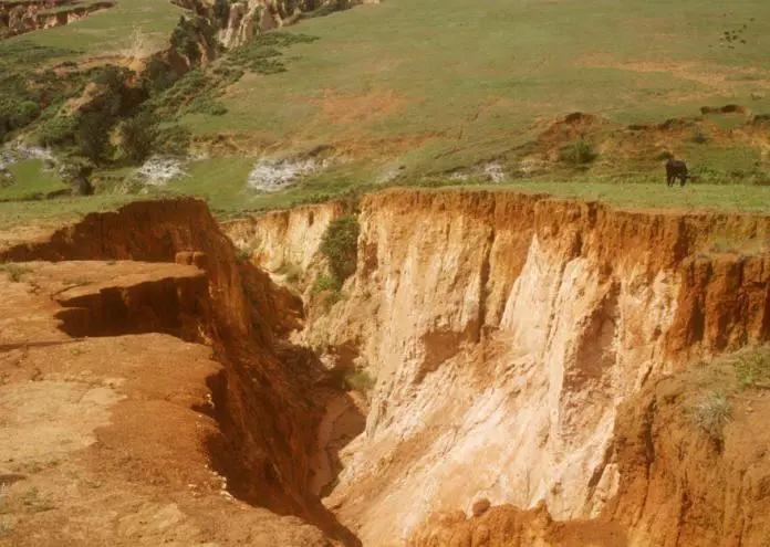
The removal and transportation of soil particles as a result of water, wind, or other physical disturbances is known as soil erosion. Water erosion tends to be more significant and problematic than wind erosion and usually occurs as sheet erosion, which is the periodic removal of thin sheets of soil over an area, or as gully erosion that forms incised channels.
Significant loss of soil due to erosion can create geohazards and affect civil engineering structures and infrastructures if not properly controlled or managed.
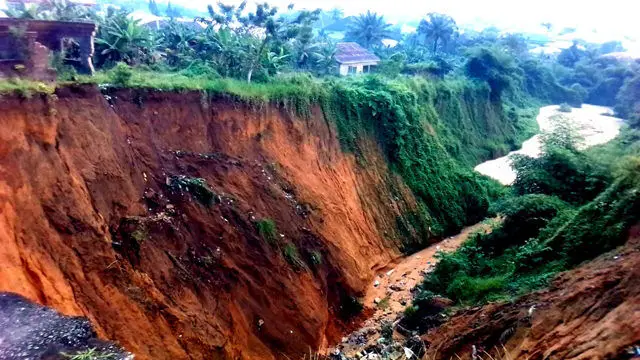
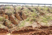
Furthermore, cropland productivity and agriculture can be harmed by soil surface erosion, and eroded soil sediments can negatively affect streams, lakes, and reservoirs. The erosion of roadside embankments can result in rills and gullies on the embankments, increased surface runoff, more soil erosion, and ultimately slope failure.
The US Department of Agriculture (USDA) developed the universal soil loss equation (USLE) to predict the soil loss caused by surface erosion. This equation has been widely used to predict the average annual rate of sheet and rill erosion in agricultural fields. The equation, which takes into account terrain, crop system, rainfall pattern, and management techniques, is written as follows:
A = R × K × (LS) × C × P
where:
A = average annual soil loss; it is conventionally expressed in tons/ac/yr,
R = rainfall and runoff factor; it depends on the rainfall intensity and duration,
K = soil erodibility factor; it represents a soil’s ability to resist erosion and is determined by the soil texture, soil structure, organic matter content, and soil permeability,
L = slope length,
S = steepness factor,
C = cover and management factor; it is the ratio of soil loss in an area with specified cover and management to the corresponding soil loss in a clean-tilled and continuously fallow condition. For bare ground, C = 1.0,
P = support practice factor; it is the ratio of soil loss with a support practice such as contouring, strip-cropping, or implementing terraces compared to up-and-down-the-slope cultivation. For construction sites such as roadside embankment, P is not used in the equation.
The USDA published the Revised Universal Soil Loss Equation (RUSLE) in the year 1996 to replace the original USLE. The RUSLE still uses the same form and factors as the original USLE, but additional data were added and the factor assessment technique was changed.
The factor K was changed to be time-varying to reflect freeze-thaw conditions and consolidations; the topographic factors for slope length and steepness, LS, were changed to reflect the ratio of rill to interrill erosion; the cover-management factor C was changed from the seasonal soil loss ratios to a continuous function that is the product of four subfactors; and the factor P was expanded to consider environmental factors.
Control of Surface Erosion
In field practice, various surface erosion control techniques are used. Innovative, cost-effective, and sustainable techniques are always emerging as research and technology progresses.
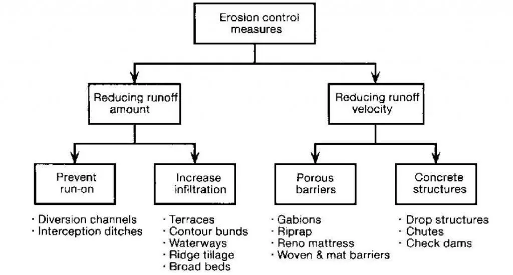
Several of the most widely used surface erosion management techniques are described in the sections below.
Riprap
Riprap is “a flexible channel or bank lining or facing consisting of a well-graded mixture of rock, broken concrete, or other material, usually dumped or hand-placed, which provides protection from erosion,” according to the US Federal Highway Administration (1989).
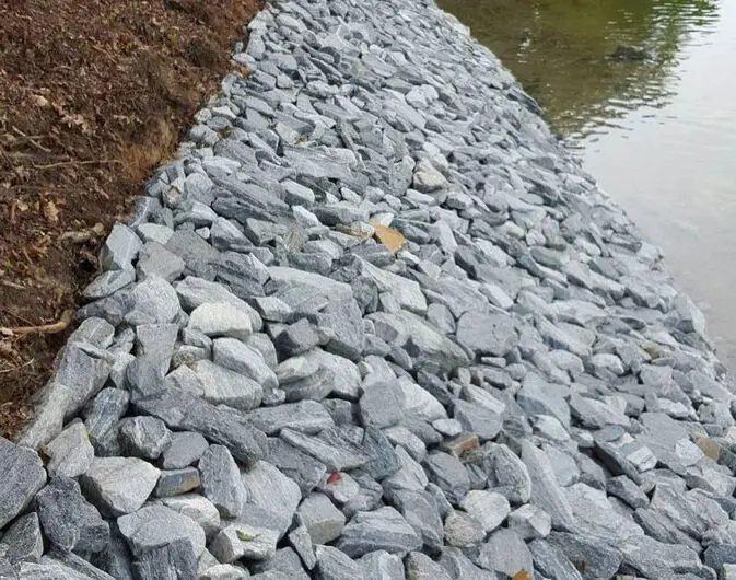
Riprap is frequently used to protect and stabilize embankments, slope drains, storm drains, and side slopes of rivers, channels, lakes, and dams. Rock riprap, wire-enclosed rock, grouted rock, precast concrete block revetments, and paved lining are some examples of riprap revetments.
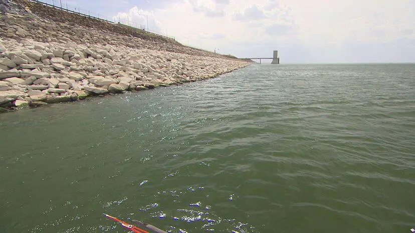
The most popular surface erosion prevention technique for river and channel banks is rock riprap. The figure above provides an illustration. The individual stones for riprap are preferably angular in shape and well-graded to allow for interlocking. Together with the weight of the stone, this interlocking property creates a strong stone layer that can withstand erosion.
On steep slopes, rock riprap can be unstable, particularly when rounded rock is used. Other materials, such as geosynthetics matting, should be taken into consideration for slopes steeper than 2:1. The following factors may be taken into account while designing rock riprap:
- Rock size
- Rock gradation
- Riprap layer thickness
- Filter design
- Material quality
- Edge treatment
- Construction considerations
The following design recommendations can be adopted for rock riprap;
• Gradation: Rather than using one consistent size of rock, use a well-graded combination of rock sizes.
• Stone quality: Use hard riprap material (most igneous stones, including granite, have appropriate durability) so that freeze-thaw cycles do not quickly disintegrate it.
• Riprap depth: The thickness of the riprap layer should be double or more than the largest stone diameter.
• Filter material: Before laying the riprap, apply a filter material, often a layer of gravel or geosynthetic fabric. This keeps the earth beneath the riprap from penetrating it.
• Riprap limits: Place riprap so that it reaches the maximum depth of the flow or until enough vegetation has grown to effectively control erosion.
• Curved flow channels: Ensure that riprap reaches upstream and downstream of the beginning and end of the curve as well as the entire curved section to five times the bottom width.
• Riprap size: The riprap material’s size varies from an average of 5 cm to 60 cm in diameter depending on the shear stress of the flows to which it will be subjected.
Compost
Composting can slow erosion and hasten the development of vegetation in highly erodible environments. During composting, microorganisms transform organic matter into a stable amendment using an aerobic process. Composting prevents waste from going to landfills and transforms waste into valuable resources with significant economic and environmental advantages.
Composts of many kinds have been used to reduce surface erosion on embankments and naturally occurring slopes. Some of them are;
(1) organic stuff composted from grass clippings and agricultural waste
(2) manure compost made from animal and plant waste,
(3) co-composting material made from biosolids and green waste, and
(4) composts made from wood chips and forestry waste.
Composts made from municipal solid waste and leftover food have both been used to control erosion. Compost’s characteristics, including pH, soluble salts, moisture content, organic matter content, maturity, stability, particle size, pathogens, physical contaminants, and other factors, can differ greatly depending on where it comes from and how it is made.
Various organizations may specify compost that is appropriate for technical uses. To assure the quality of the finished dry compost, the USDA and the United States Compost Council (USCC) have established the “Test Methods for the Examination of Composting and Compost.”
Vegetation Cover
Another popular erosion control strategy is vegetation. It protects the soil surface from raindrop impact, shields the soil surface from overland flow’s scouring effect, and reduces the velocity of the flowing water to decrease its erosive capacity. In addition to strengthening the soil’s ability to withstand erosion and enhance the rate of infiltration, vegetation roots can also reduce runoff.
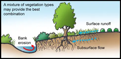
Vegetative cover is more aesthetically pleasing and is relatively easy to achieve and maintain. It is frequently combined with other erosion control techniques such as mulches, geosynthetic coverings, and blankets made of compost.

The following elements should be taken into account while designing and installing vegetative covers:
• Acidity, moisture retention, drainage, texture, organic matter, and fertility of the soil.
• The state of the site, specifically its slopes and vegetative cover.
• Climate factors like wind, precipitation, and temperature.
• Species choice, which is influenced by the local climate, planting seasons, water demand, soil preparation, weed management, post-construction land usage, and anticipated maintenance requirements, such as irrigation and cost.
• Methods of the establishment.
• The maintenance techniques.
Geosynthetics
Geosynthetics can be conveniently employed for slope stabilization, erosion control, and sediment management. Geosynthetics can be used in many different ways, and new ways are always being developed. Examples include hard armors, nondegradable RECPs, and degradable rolling erosion control products (RECPs).
On rehabilitated lakeshores, riverbanks, and alongside recently built roadsides, degradable materials can be utilized to improve the development of flora. When vegetation alone can adequately protect a site after an erosion control material has deteriorated, then degradable materials can be utilized.
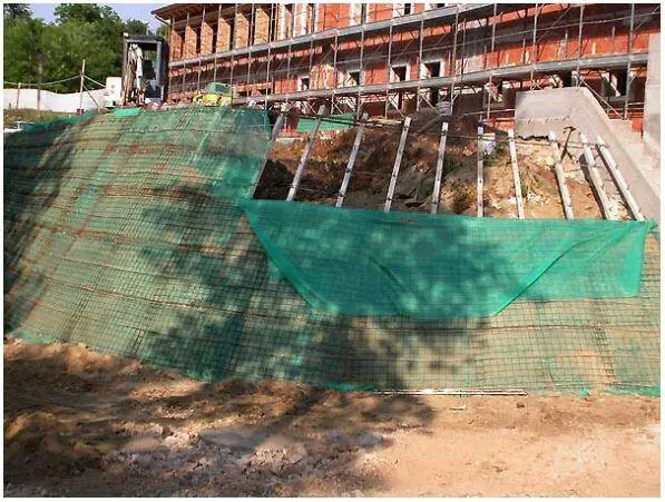
However, products that are not biodegradable offer vegetation long-term reinforcement. They are used in more difficult erosion control situations when immediate, high-performance erosion protection is required. By permanently bolstering the vegetative root system, the materials increase the erosion resistance of soil, rock, and other materials.
The use of geosynthetic erosion control measures frequently performs multiple functions, such as collecting and draining surface runoff, filtration, separating, strengthening, and establishing and maintaining vegetation coverings.
Soil Binders
Soil binders (materials with cementation properties) can be used to increase the resistance of a soil matrix to water and pressure. Soil binders are used to hold soil particles together and can be used for soil stabilisation and erosion control. The usage of stabilized soil and the local environmental conditions have a big impact on how well conventional soil binder applications work.
Cement is a common binder used in construction despite its several environmental disadvantages. Quicklime, hydrated lime, and lime slurry are the compounds used as lime-soil binders. Due to its weak resistance to the abrasive effect of traffic, fly ash is primarily employed to stabilize subbase or subgrade; it is not among the soil binder products suited for surface stabilisation.
Erosion Control Structures
Numerous structural measures can be used as either temporary or permanent installations for erosion control. There are many different forms of grade control structures, such as diversions, grassed or paved streams, buried pipe outlets, bench terraces or berms, retarding structures, debris basins, and many others. In the sections that follow, it will be explained where and how some of these measurements might be employed, as well as the placement and design criteria;
Diversions
Diversions are constructed over a slope in the form of graded channels with a supporting ridge on the lower side. They provide the function of collecting surface or subsurface water and directing it to a discharge point where it can be safely disposed of. These structures can be level or graded, temporary or permanent. While level terraces have closed ends and hold runoff, graded terraces transport water in a predetermined direction at a non-erosive velocity.
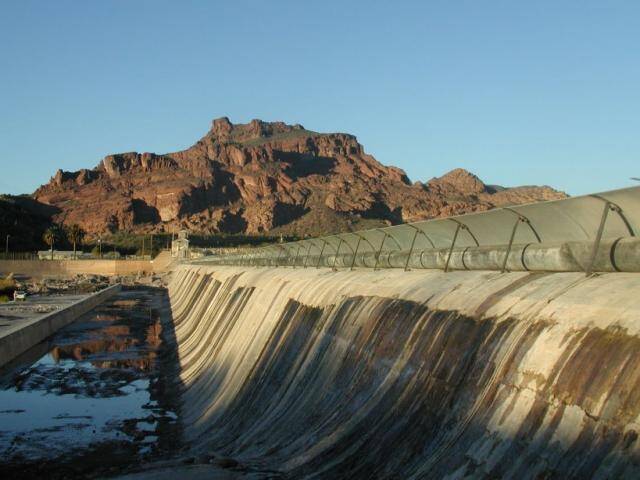
Diversions are helpful above borrow zones, gully heads, and cut slopes. They can be used to divert runoff water away from crucial construction sites and can be built across cut slopes to reduce slope length into non-erosive segments. They could be constructed on-site or off-site.
Water should empty from diversion points into prepared individual outlets, established disposal zones, or natural outlets. Individual outlets could be constructed as chutes, paved or grassed streams, or underground pipes. Diversion should be designed to handle rainwater with a return period of 10 years.
Berms
Steps or benches found on steep slopes are called berms. They are a variation of diversions and accomplish essentially the same thing. They shorten slope lengths and divide runoff water volume into manageable slugs when placed and designed properly.
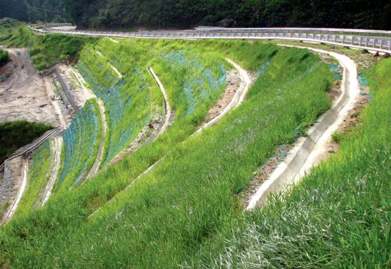
Grading the berm in such a way that the outside edge is higher than the edge next to the cut slope gives it the capacity to carry the volume of water. By burying a pipe or using paved canals, runoff water from the berm can be removed.
Waterways
Waterways act as outlets for berms, diversions, and other constructions. They can be constructed or naturally occurring, shaped to the necessary size, and covered in vegetation or asphalt to collect runoff water. They are often built into one of the following common cross sections: rectangular, parabolic, trapezoidal, or V-shaped. Parabolic waterways are most frequently used in areas that will be vegetated and it is the shape that commonly occurs in nature.
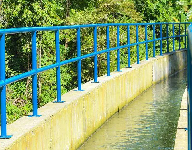
Protection from erosion is essential for the efficient operation of a waterway. This can be achieved by paving with concrete or rock or by establishing flow velocities that are benign for the grass that will be employed. Waterways ought to be built at least to handle the runoff from a rain event with a 10-year frequency.
Debris Basin
A debris basin is used to temporarily hold runoff water that contains substantial amounts of silt, sand, or gravel. Typically, it consists of a primary spillway made of perforated pipe and an earth embankment. Upon entering the impoundment, runoff water slows. The water is automatically pushed out through the main spillway as a substantial portion of the debris settles out.
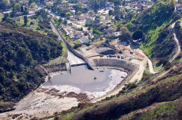
Measures should be provided for periodic cleanup of the drainage basin, or the structure should be built to store the anticipated debris yield over the duration of the construction. There are both permanent and temporary debris basins. Those used to contain construction-related debris are often temporary and are demobilised when the project is finished and the region has stabilized.
Retarding Structures
A retarding structure is made up of earth embankment, a main spillway, and an emergency spillway structure. They could be built on-site or off-site. Their function is to temporarily retain runoff and then slowly release it to protect the land below. They can lower runoff peaks, allowing for the use of smaller bridges and culverts.
It is possible to do away with bridges and possibly save money if retarding structures are built on-site and the roadbed is filled. Cooperation from locals and groups like soil and water conservation districts will be required because any one of the structures has a variety of community benefits, including flood mitigation, grade control, and water for cattle, recreation, and irrigation. This kind of collaboration is encouraged by memorandums of understanding that a number of state transportation departments have with respective conservation organizations.
The main spillway typically comprises an earth fill exit and a horizontal pipe or monolithic concrete outflow made of reinforced concrete. The retarding storage space is typically intended to be empty in 10 days or fewer. The emergency spillway should, at the very least, be able to manage the routed runoff from a storm with a 25-year frequency or from a storm with a frequency equal to the structure’s design life, whichever is higher.
The runoff anticipated to occur at a frequency consistent with the level of protection to be offered should be able to be contained by the retarding storage.
Grade Stabilisation Structures
Structures for grade stabilization maintain grade or manage head cutting in both natural and man-made channels. They literally step runoff water down a hill at a regulated rate while lowering channel grade and flow velocity.
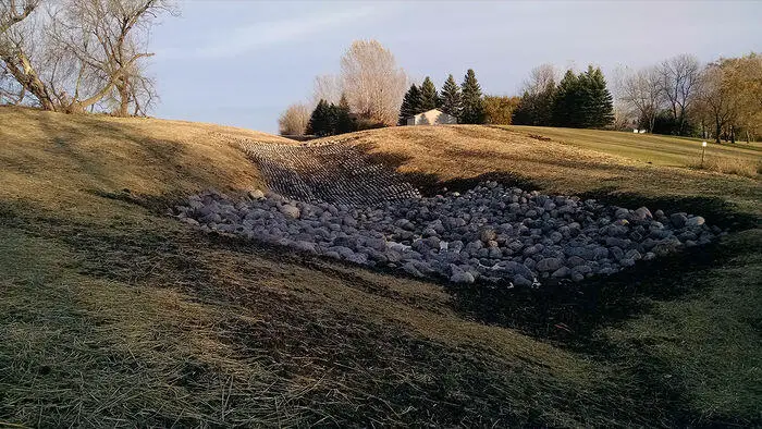
Earth embankments with pipe spillways or mechanical structures made of concrete, masonry, steel, aluminium, or treated wood are examples of grade stabilization systems. Although the design is dependent on site conditions, these structures should typically be able to manage storm runoff with a 25-year return period.
Gabions
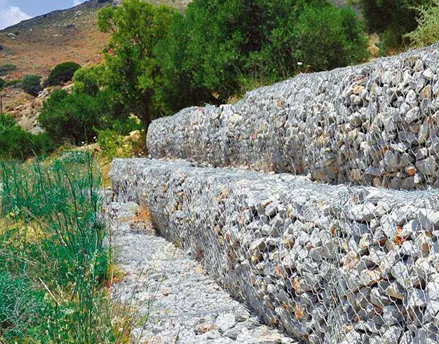
Gabions are riprap (natural stones) contained in cages or cylinders made of galvanized steel-wire mesh. These are employed to prevent erosion on slopes, stream banks, or shorelines. Instead of being stacked vertically, they are typically positioned on slopes at an angle—either damaged or stepped back. The wireframe (cage) of a gabion determines how long it will last, and quality gabions have a fifty-year structural stability guarantee.
Conclusion
Erosion is the loss of soil due to the dislodgement and transportation of soil from one site to another. As soil erodes, soil nutrients are lost, rivers become clogged with dirt, and finally, the area becomes a desert or in the case of deep gullies, the area becomes uninhabitable.
Though erosion occurs naturally, human activity has the potential to significantly worsen it. Land that was once healthy and alive can become parched and lifeless due to erosion, which can also lead to mudslides and landslides.
When the proper techniques, equipment, and approaches are applied at the appropriate times, erosion can be easily managed on a construction site. Planting vegetation is the most natural and efficient technique to control erosion. Plant roots, particularly those of trees, cling to the earth and can effectively stop excessive soil movement.






i realy appreciated your notes about erosion and ground water controls.
Thank you for providing this valuable information.